Tiger Hill : Situated at an altitude of 2590 metres (8482 ft.), it is 15 km from Darjeeling town. An early morning trip to the Tiger Hill promises an unique experience. A view of the sunrise amidst the Himalayan range has earned it an international fame. From here you can get a glimpse of Mount Everest, the highest mountain and Kanchenjunga range.
The Observatory Hill
Prayer flags fly in the winds at Observatory Hill
The Observatory Hill : Apart from the magnificent view it commands, this hill atop the Mall also is attached with great religious importance as a revered temple complex for both the Hindus and the Buddhists.
Darjeeling Himalayan Railway or the Toy Train : This fascinating narrow gauge steam engine train still operates with the original steam engine and the loops and the zigzags along the route are remarkable feats of engineering. The journey from New Jalpaiguri may be a pleasant experience but it is the short ride from Darjeeling town to Ghoom, the nearest station, that becomes a joy ride in itself. The Toy Train is considered an engineering marvel and some prefer to call it one of the wonders of the world, to be preserved forever.
Batasia Loop and the War Memorial : About 5 kms. from Darjeeling, this railway loop is a marvellous feat of engineering and with its magnificent view of Darjeeling town with the Kanchenjunga mountain is worth an experience, whether aboard the Toy Train or just watching the Toy Train pass through this loop. The War memorial is constructed in the memory of the brave sons of Darjeeling who died for the country since Independence in 1947.
Tea Gardens : While in Darjeeling a visit to any nearby Tea Garden to watch the actual process of the manufacturing of Darjeeling Tea is worth it. Some of the Tea Gardens also sell their packet teas. There are about 70 tea gardens in this hill region and the most accessible one is the Happy Valley Tea Estate, which is about 3 kms. from the town or within a walking distance of about 40 minutes (Closed on Monday).
Buddhist Monasteries : In and around Darjeeling there are important and interesting Tibetan Buddhist Monasteries. The oldest one is called the Yiga Cholling Monastery which is situated about 8 kms. from the town at Ghoom and enshrines an image of 'the Coming Buddha' or the Maitriya Buddha. It was constructed in 1875 and belongs to the Gelugpa Sect. The Samten Cholling Monastery is another interesting monastery nearby. The Drukpa Kargyud Monastery, also known as Dali Monastery, is a big monastery located 5 kms. from the town. It belongs to the Drukpa Sect and the Drukchen Rimpoche resides here. The Bhutia Busty Monastery is situated at C.R. Das Road and is within 15 minutes walk from the Mall.
Yiga Cholling Monastery
Yiga Cholling Monastery in Ghoom
Japanese Peace Pagoda : The Nipponzan Myohoji Buddhist inaugurated the Japanese Peace Pagoda in 1992. It is a recent landmark constructed by Japanese Monks and commands an excellent view of the town and the Himalayan Range.
Dhirdham Temple : Situated just below the Railway station the temple is a structural replica of the famous 'Pashupatinath' temple of Kathmandu, Nepal.
View from The Mall
A view from The Mall
The Mall and Chowrasta : The Mall road originates and culminates at the Chowrasta which is the hub of Darjeeling town, a square on the ridge of Darjeeling town and a good place to sit and relax. It is ideal for a leisurely walk around a setting that is perfect. A walk around The Mall is a must just at any time of the day with the pleasant view of the mountains, valleys with rhododendron trees and old houses.
Natural History Museum : While taking a walk in The Mall a visit to the Museum of Natural History which lies closeby is worthwhile. This fine small museum exhibits an unique collection of the fauna of the Himalayan region, especially of the Eastern Himalayas.
Himalayan Mountaineering Institute : It was founded in 1954 after the historic conquest of Everest on the 29th of May in 1953, when two people set foot atop Mount Everest. They were, Tenzing Norgay (Sherpa) from Darjeeling and Sir Edmund Hillary from New Zealand. As an honour to the great Sherpa this Institute was formed with the aim of imparting mountaineering skills to all the enthusiasts. Tenzing Sherpa himself was one of the founding members and also the Field Director of the Institute. It is situated on Jawahar Parbat and adjoins the Zoo. This Institute also houses a museum which holds a rare collection of mementos from various Everest expeditions. Nawang Gombu, the first man to have climbed the Everest twice is presently the Chief Advisor for the Mountaineering Training.
Himalayan Zoological Park and Snow Leopard Breeding Centre : A high altitude wild life park and new home of the Siberian Tiger, Himalayan Black Bear, Barking Deer etc. , Padmaja Naidu Himalayan Zoological Park or the town Zoo exhibits some rare Himalayan Fauna including the Snow Leopard, Red panda, Tibetan Wolf, Himalayan Pheasants, etc. It is a treat for all wild life enthusiasts. Just nearby is a very successful Snow Leopard Breeding Centre.
Lloyds Botanical Garden : This is a colourful garden situated just below the market. In 1878 Mr. W. Lloyd gifted 40 acres of hillside to make a garden with local plants and flowers. It still has the most varied collection of rhododendron, magnolia, orchids, etc. of the Eastern Himalayas. It also has a glass-house full of alpine flowers and also features an Orchidarium and a collection of medicinal plants.
Lloyds Botanical Garden
Lloyds Botanical Garden
Darjeeling Rangeet Valley Passenger Ropeway : This Ropeway is in one of the most beautiful part of the town and is situated at North Point about 3 kms. from town. The cable car ride takes 6 passengers at a time and it passes over the lush green tea gardens with breathtaking view of the mountains (Kanchenjunga) and provides an experience that cannot be easily forgotten. The valley has glorious views of Sikkim and the river Rangeet.
Carpet Weaving
Carpet weaving at Tibetan Refugee Self Help Centre
Handicrafts : Darjeeling has some interesting places to watch the local handicrafts being made as well as a various range of choiced handicraft souvenirs. The Tibetan Refugee Self Help Centre is a self-supporting Centre for Tibetan refugees which manufactures some intriguing Tibetan handicrafts. Established for the rehabilitation of Tibetan refugees who had followed the Dalai Lama to India in early 1959. It offers a wide choice of Tibetan handicrafts, Tibetan woollen carpet is very popular. Hayden Hall, a Roman Catholic social service centre also has a handicraft section with the purpose of helping the local poor people.
Handmade items are available for sale at reasonable prices. The Manjusha Bengal Emporium offers prominent hill handicrafts, handloom and silk products of West Bengal for display and for sale. It is situated at Nehru Road. Gram Shilpa is another such showroom displaying Khadi handloom silk products and set up by the Khadi and Village Industries Commission, Govt. of India. It is situated in Chowrasta.
Ava Art Gallery : Approximately 10 minutes by taxi from the motor stand, it is just below the main road on the way to Ghoom. This gallery houses fine art and embroidery work of Mrs. Ava Devi.
Sunday, June 7, 2009
Darjeeling


Saturday, June 6, 2009
Nepal Tourist Attractions
There are many beautiful and interesting places, to visit outside the Kathmandu Valley - places of historical importance of noted for natural beauty. Most of them can be easily reached from Kathmandu by road or by air.
Kakani:
Located 29-km north-west of the Kathmandu city, the fabulous holidays area of Kakani features attractions ranging from beautiful alpine scenery to the magnificent Himalayan panorama particularly of the Ganesh Himal massif. Other peaks that can be closely seen from Kakani are: Gaurishanker (7,134m.), Choba Bhamre (6,109 m), Manaslu (8,163 m), Himalchuli (7, 893m), Annapurna ( 8,091m), and several other peaks.
Gosainkunda:
One of the most famous religious places of pilgrimage of Nepal is Gosainkunda lake, situated at an altitude of about 4,360m. The best approach to Gosainkunda is through Dhunche, 132-kms north east of Kathmandu.
Dhunche is linked with Kathmandu by a motorable road. Surrounded by high mountains on the north and the south the lake is grand and picturesque. There are other nine famous lakes such as Saraswati Bhairv, Sourya and Ganesh Kund, etc.
Dhulikhel:
This ancient town is situated 30-km east of Kathmandu on the side of the Arniko Rajmarga (Kathmandu-Kodari highway). From here one can have a complete panoramic view of the snowy ranges from Karyolung in the east to Himalchuli in the west.
Panauti:
It is a thriving village of the road to Dhulikhel, with some very lovely temples and interesting old houses particularly beautiful area some 14th century wooden temple struts. The drive is through beautiful countryside.
Namo Buddha:
It is situated on a hill above Panauti. It requires an easy drive or good walk to get here. There is an amazing story concerned with the Buddha which is commemorated by an ancient stone slab and a stupa with the all seeing eyes of Lord Buddha.
Timal Narayan:
The route from Dhulikhel to Timal Narayan is ideal for a short trek. From here one can have a beautiful view of Gaurishanker Himal and other important peaks as well as Sunkoshi river. It is also very pleasant to visit to the village of the tamang people who live in this area.
Palanchowk Bhagawati:
7-km north of the mountain of Panchkhal, on the top of a hill lies the noted historic temple of palanchowk bhagawati. The temple houses a three feet long beautiful artistic stone image of goddess bhagawati.
Charikot:
About 133-km from Kathmandu, Charikot provides a spetacular mountais view of the Gaurishanker. In the eastern upper part of Dolakha township there is a famous roofless temple of Dolakha Bhimsen.
Helambu:
HelambuHelambu situated about 72-km north-east of Kathmandu is famous for its scenic grandeur and pleasant climate. There are many Buddhist monasteries amidst a rich and enchanting landscape. Sundarijal is the starting point to trek to Helambu which is mere 11-km away from Kathmandu.
Gorkha:
Gorkha is the birth place of King Prithivi Narayan Shah - The Great, the founder of modern Nepal. Situated on a hill overlooking the snowy peaks of the himalayas, there is a beautiful old palace known as Gorkha Durbar. There are two attractive temples of Gorakhnath and Kali inside the palace precinct. Only Hindus are allowed inside the temple of Gorakhnath. Gorkha can be reached in about 6 hours from Kathmandu and in about 4 hours from Pokhara. A side trip to Manakamana on the way to Gorkha is very enjoyable and interesting.
Muktinath:
The famous temple of Lord Muktinath lies in the district of mustang and is situated about 18-kms north-east of Jomsom at an altitude of about 3,749m. The temple is situated on a high mountain range and is visited during fair weather.
There are two ways to get to Muktinath from Kathmandu. Either to take a direct flight from Kathmandu via Pokhara to Jomsom and hike for a couple of hours via Kagbeni or to trek all the way from Pokhara. There is also air service from Pokhara. There is also air service from Pokhara to Jomsom.
Pokhara Valley:
The Pokhara Valley one of the most picturesques spot of Nepal, is enhanced by its lovely lakes Phewa, Begnas and Rupa. Situated 200-kms west of Kathmandu, Pokhara is connected by air as well or by bus from Kathmandu and Bhairahawa a border town near India. Situated at an altitude of 827m, Pokhara offers the magnificent views of Dhaulagiri, Manaslu, Machhapuchhre, five peaks of Annapurna and others. Pokhara?s numerous lakes known as ?Tal? in Nepali offer fishing, boating and swimming.
Tansen:
Situated at an altitude of 1,343m, Tansen is the most popular summer resort in western nepal on account of its position and climate. It has perhaps Nepal?s most far stretching views of the country?s chief attractions. The Himalayas from Dhaulagiri in the west to Gaurishanker in the north-east. It takes just seven hours by bus from Pokhara to reach Tansen.
Lumbini:
LumbiniLumbini is the birth place of Lord Buddha, the apostle of peace, and non violence. It is situated 250-kms south-west of Kathmandu. The broken Ashokan Pillar, remnants of old monastery, images of Buddha?s mother Maya Devi, etc. are still preserved in Lumbini. It is accessible by air from Kathmandu to Bhairahawa. Also one can reach Lumbini in about 3 hours by bus or car from Tensen via Bhairahawa. From Kathmandu it takes about 8 hours by bus or car.
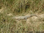
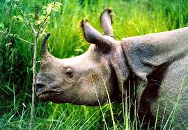
Rapti Valley (Chitwan):
From Kathmandu it takes 6 hours to reach chitwan. Situated 120-kms south-west of Kathmandu, the main attraction of chitwan is Royal Chitwan National Park. This is one of the Nepal?s largest forest regions with a wide range of wildlife - the rare great One-horned Rhinoceros, several species of Deer, Sloth Bear, Leopard, Wild Boar, Fresh Water Dolphin, Crocodile, more Royal Bengal Tiger. Visitors to chitwan may view game of Elephant back excursions, nature walks, canoe trips, from window and on jungle treks. There are several authorized agencies to organize such safari. Visitors may also take river raft, driving from Kathmandu to the river Trishuli or Seti Khola.
Daman:
It is situated 80-kms south-west of Kathmandu at an altitude of about 2,400m. Daman is located on the Tribhuvan highway in between Kathmandu and the town of Birgunj. For the view of the breathtaking grandeur of the world?s highest peaks extending in one glittering are from far west of Dhaulagiri to far east of Sagarmatha (Mt. Everest) there is no better place than Daman. There is a view tower fitted with long range telescopes. Daman can be reached in four hours from Kathmandu.
Namche Bazaar:
Mount EverestThe name of namche bazaar is generally associated with that of Sagarmatha or Mt. Everest - the highest peak in the world. It is the entrance to the Everest region. Situated on the lap of Khumbu Himal range, Namche Bazaar is about 241-kms. From Kathmandu and the distance is generally covered within 15 days by trekking. This place is the home of the legendary Sherpas. One can fly from Kathmandu to Lukla and Syangboche in the Everest region.
Janakpur:
A great religious place, Janakpur is famous as the birthplace of Goddess Sita, the consort of Lord Ram. There is an artistic marble temple of Sita (Janaki), popularly known as Naulakha Mandir. Religious festivals, pilgrimages, trade fairs and other festivities are held here on Bivaha Panchami and Ram Navami days.
Biratnagar:
The second largest city of Nepal Biratnagar is situated in the Koshi Zone. The city has some of the largest industrial undertakings in the country. There are a couple of pilgrimage spots in dharan and barahachhetra nearby the city. Biratnager is linked with kathmandu by air and road.
Barahachhetra:
A few kilometers from the main city of Biratnagar, Barahachhetra, the holy place of Hindu pilgrimage, lies at the confluence of the two rivers the Saptakoshi and Kokaha. There is the temple of Lord Baraha, the boar incarnation of Lord Vishnu. Historians have traced the existence of this image from the 12th century.
Hile:
It is situated about 13-kms north of Dhankuta Bazaar. The panorama of the major peaks of the eastern Himalayas including Sagarmatha or Mt. Everest, Makalu, Lhotse and Kumbhakarna.
Antu Danda:
It is situated at an altitude of 1,677 m. In the llam district and is famous for its unique views of everest and kanchenjunga. It is the best place for viewing sunrise and sunset.
Nepal Bungy Jumping
Bungy Jumping
If you thought bungy jumping was restricted to some places in Europe, New Zealand and America, it's time you got and update. The sport has finally found a natural home in the highest mountain range in the world. The ultimate thrill of a bungy jump can now be experienced in Nepal at perhaps the best site in the world.
Nepal's first bungy jumping site is situated 160m over the wild Bhote Kosi river, and located close to the Nepal-Tibet border, a three-hour bus ride from Kathmandu. As can be arranged on arrival in Kathmandu. As of now, there is only one agency offering this sport. The jump, at 160m, was designed by one of New Zealand's leading bungy consultants, and is operated by some of the most experienced jump masters in the business. It's mishap-proof. The agency takes safety "very, very seriously".
Location
Less than 3 hours outside Kathmandu by Ultimate Bungy Shuttle. You will travel the Arniko (Kathmandu/Lhasa) Highway to within 12km of the Tibet Border and the famous Friendship Bridge.
The Gorge
Ultimate Bungy Nepal takes place on a 166m wide steel suspension bridge over the Bhoti Kosi River.
The Bridge
Swiss designed, specially for bungy jumping with a 4x saftey factor. The bridge has a loading factor of 250kg per running meter. This means that the bridge will hold 250 x 166 = 41,500kg or 4.5 tonnes. And... those are Swiss measurements! * Over 6000 meters of steel wire was used to build the bridge * Longest suspension bridge in Nepal * The bridge joins two sides of a great valley. Before its construction, locals walked five hours to cross this river gorge.


Royal Chitwan National Park
Introduction:
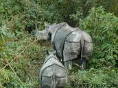
Royal Chitwan National Park stands today as a successful testimony of nature conservation in South Asia. This is the first national park of Nepal established in 1973 to preserve a unique ecosystem significantly valuable to the whole world. The park covering a pristine area of 932 sq. km is situated in the subtropical inner Terai lowlands of southern central part of Nepal. The park has gained much wider recognition in the world when UNESCO included this area on the list of World Heritage Site in 1984.
Formerly, the Chitwan valley was well known for big game and was exclusively managed as a hunting reserve for the Rana Prime Ministers and their guests until 1950. In 1963, the area south of Rapti was demarcated as a rhinoceros sanctuary. In 1970, His late Majesty King Mahendra had approved in principle the creation of Royal Chitwan National Park.
The park consists of churia hills, ox-bow lakes, flood plains of Rapti, Reu and Narayani rivers. The Churia hill rises gradually towards the east from 150 m to over 800 m. The lower but most rugged Someshwor hills occupy most of the western portion of the park. The flood plains of Chitwan are rich alluvial. The park boundaries have been delineated by the Narayani and Rapti rivers in the north and west, and the Reu river and Someshwor hills in the south and south-west. It shares its eastern border with Parsa Wildlife Reserve.
Vegetation and Animals:
* The Chitwan valley is characterized by tropical to subtropical forest. 70% of park vegetation is predominantly Sal ( Shorea robusta ) forest, a moist deciduous climax vegetation type of the Terai region. The remaining vegetation types include grassland (20%), riverine forest (7%) and Sal with Chirpine ( Pinus roxburghii ) (3%), the latter occurring at the top of the Churia range. The riverine forests mainly consists of khair, sissoo and simal. The simal is with spiny bark when young and develops buttress at the bottom in older stage. The grasslands form a diverse and complex community with over 50 species. The Sacchrum species, often called elephant-grass can reach 8 m in height. The shorter grasses such as Imperata is useful for thatch roofs.
* There are more than 43 species of mammals in the park. The park is specially renowned for the protection of the endangered one-horned rhinoceros, tiger, gharial crocodile along with many other common species of wild animals. The estimated population of endangered species of animals such as gaur, wild elephant, four horned antelope, striped hyena, pangolin, gangetic dolphin, monitor lizard and python, etc.
* Some of the other animals found in the park are samber, chital, hog deer, barking deer, sloth bear, common leopard, ratel, palm civet, wild dog, langur, rhesus monkey, etc.
* There are over 450 species of birds in the park. Among the endangered birds found in the park are Bengal florican, giant hornbill, lesser florican, black stork and white stork, Few of the common birds seen are peafowl, red jungle fowl, and different species of egrets, herons, kingfishers, flycatchers and woodpeckers. The best time for bird watching is March and December.
* More than 45 species of amphibians and reptiles occur in the park and some of which are marsh mugger crocodile, cobra, green pit viper and various species of frogs and tortoises.
* The park is actively engaged in the scientific studies of several species of wild flora and fauna.
Seasons:
* The park is under the tropical monsoon climate with relatively high humidity. The winter, spring and monsoon are the three main seasons. The cool winter season occurs from October to February. The spring begins in March and is soon followed by summer that ends in early June. The summer days are typically hot with 30 C on average day temperature. The monsoon usually begins at the end of June and continues until September. The mean annual rainfall is about 2150 mm and during this time of the year rivers are flooded and most of the roads are virtually closed.
How to Get There:
* The park is accessible by car or bus on the Kathmandu-Mugling-Narayanghat Highway and or through Mahendra Rajmarg Highway from Hetauda. It is about 6 hour's drive from Kathmandu to Narayanghat. Local buses are available to Tadi Bazar which is about an hour drive form Narayanghat. A 6 km walk or bullockcart ride brings the visitors to Sauraha, the park entrance. Also air services from Kathmandu to Meghauli for US$82 each way and Bharatpur US$65 each way are available. Local buses are available form Narayanghat to Park HQ. Kasara.
Park Facilities:
* Display Center, Kasara
* Library at Kasara Sauraha
* Visitor Center, Sauraha
* Machans (View tower)
Activities:
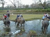
* Elephant ride
* Canoeing
* Guided jungle walk
* Terai culture
* Wildlife breeding projects
* 4WD safaris
Enrty fees into Royal Chitwan National Park:
* National Park entry fee per person per day:
* For Nepali Nationals Rs 20
* For SAARC NAtionals Rs 200
* For Foreign Nationals Rs 500
* Children under 10 years Free
* Elephant ride for about 2 hrs. - Rs 550 - (Nepali's Rs 100)
* Fishing permit - Rs 300 - (Nepali's Rs 20)
* Camping per night per person - Rs 300 - (Nepali's Rs 20)
* Guided jungle walk - Rs 250/400 for half day/full day - (Nepali's Rs 20)
* Canoeing - Rs 230 per person
* 4WD safari - Rs 650 per person
* Gharial crocodile breeding centre - included in the park entrance fee
* Elephant breeding centre - included in the park entrance fee
* Lodges offer all-inclusive packages for 2 to 4 days for those who want everything pre- organised by the lodge guides.
Thursday, June 4, 2009
Mountains of Nepal
The Himalayas(Mountains in Nepal)
The Himalayas or "abode of snow" is in fact the youngest and highest mountain system in the world. It extends over 2,400kms as a vast south-facing area between the Indus and Brahmaputra rivers with Nanga Parbat (8,125m) and Namcha Barwa (7,755m) as its terminal high points. Fully a third of 800kms of its central section traverses Nepal and is known as the Nepal Himalayas, Here congregate more than 250 peaks that exceed 6,000m in height-a unique concentration of lofty dazzling summits. Of the thirty one Himalayan peaks over 7,600m, twenty-two like in Nepal Himalayas including eight of the world's fourteen highest giants. These are:
Sagarmatha(Mt. Everest) 8,848m
Kanchenjunga 8,586m
Lhotse 8,516m
Makalu 8,463m
Cho Oyu 8,201m
Dhaulagiri 8,167m
Manaslu 8,163m
Annapurna 8,091m
The Himalayan range within Nepal fits into a geographic pattern as the culmination of a series of parallel ranges. The main mountain region, represented by the eternal ranges, lies about 90kms north of the Mahabharat Lekh. The intervening space between the two parallel ranges is made up of the lower belt of the low hills (Pahar) and the higher belt of elevated ridges (Lekh) that provide the first intimation of the high snow continuous range but rather a chain of lofty ridges separated by deep gorges. Each of these mountain chains or Himals in turn sends out a maze of spurs studded with numerous peaks.
In the western and central Nepal, there is yet another mountain range that defines the boundary between Nepal and China. This border range has elevations ranging from 5,000 to 6,000m with comparatively less rugged relief but a harsh climate. Between the main Himalayan range and these border ranges lie some of the elevated Bhot Valleys.
Much of the high country above 5,000m is under the realm of snow and ice although the permanent snow line may vary according to aspect and gradient. Winter snowfall occurs up to an elevation of 2,000m and is much heavier in the western part. While winter is harsh and bitter, summer is the season of alpine flowers and is the time of the year when the high pastures teem with grazing animals from lower valleys. For the mountain communities, it is the time for harvesting their main crop before their winter migration to warmer climates

About Lumbini
About Lumbini
Lumbini is located in the south-central Terai of Nepal, situated in the foothills of the Himalayas. For millions of Buddhists the world over, it evokes a kind of holy sentiment akin to the significance of Jerusalem to Christians and Mecca to Muslims. Lumbini is the place where Lord Buddha - the apostle of peace, and the Light of Asia - was born in 623 B.C. In historical terms, the region is an exquisite treasure-trove of ancient ruins and antiquities, dating back to the pre-Christian era. The site (Lumbini Grove) was described as a beautiful garden in the Buddha's time and still retains its legendary charm and beauty. Both the Shakyas and Kolias Clans owned the garden and its tranquil environs at the time of Lord Buddha's birth. King Suddhodana, father of Buddha was of the Shakya Dynasty belonging to the Kshatriya or Warrior Caste.
For centuries, Buddhists the world over knew that the general area of Lumbini was where the Lord was born. In the words of those famous Chinese pilgrims of antiquity, Huian Tsang and Faeihan, 'Lumbini -where the Lord was born - is a piece of Heaven on Earth, where one could see the snowy mountains amidst a splendid garden, embedded with stupas and monasteries!' However, the exact location remained uncertain and obscure until 1 December 1886 when a wandering German archaeologist Dr. Alois A. Fuhrer came across a stone pillar and ascertained beyond doubt it was indeed the birthplace of Lord Buddha. Since that day it has become a focal point for hundreds of thousands of pilgrims.
Lumbini is the fourth largest tourist destination in Nepal. Nearly 20,000 tourists visit the area every year (Source: Nepal Tourism Board). Recently, UNESCO has declared it a World Heritage Site. It has great potential to grow as the major tourist destination in years to come.
The significance of Lumbini
Many of the places that were of importance to the Lord Buddha during his life retain a potent significance to Buddhists of today. Unsurprisingly, nowhere has a greater significance than the site of his birth. In the words of Buddha himself: "O-Bhikshus', after my death when people and members of a new generation come and ask you, then tell them that here the Buddha was born, here he attained the full enlightenment, here he turned the wheel of Dharma twelve times, and here finally the Buddha entered into Parinirvana". Hundreds of years have gone by, but the architectural splendours of that era are still standing and serve as a vivid reminder of the origins of Buddhist philosophy and doctrines. As a complement to the temples and shrines, our aim is to create a living environment in which Buddha would have felt at home during his life.
About Pokhara
About Pokhara - One of the wonderful place Of World
About Pokhara: Pokhara valley occupies the central location in Nepal and is dominated by the peaks of Annapurna range. Its unique setting may be judged from the fact that the town of Pokhara (91 3 metres), is only fifty kilometres from Annapurna 1 (8,091 metres), clearly seen from the valley. There is a decline of six thousand metres in altitude within a short distance of only twenty-nine kilometres; thus the region provides a dramatic contrast in landscape. The northern horizon is defined by a seventy kilometres long wall of snow and ice with numerous peaks. The prominent peaks from east to west are Annapurna South (7,21 9 metres), Fang (7,647 metres), Annapurna 1 (8,091 metres), Rock Noir (7,454 metres), Glacier Dome (7,193 metres), Gangapurna (7,455 metres), Annapurna Ill (7,555 metres), Machhapuchhre (6,997 metres), Annapurna IV (7,525 metres), Annapurna 11 (7,937 metres) and Lamjung Himal (6,983 metres). In addition to these, Dhaulagiri 1 to the north-west and Manaslu-Himalchuli peaks to the north-east are also visible.
Lakes: Pokhara valley abounds in lakes. Phewa, Rupa and Begnas are the most famous ones while Khaste, Dipang and Mardi are some other smaller lakes situated further away. Sporting activities like canoeing and swimming are conducted on Phewa Lake, together with angling of carp fish. On a small island is a temple dedicated to Varahi, and in contrast to the gaiety of holiday makers, devotees go about their worship undisturbed by the goings-on in the water as well as occasional barbeques on the banks of the lake. Apart from the lakes, the floor of the valley is made up of a layer of gravel, cut into intricate terraces and deep canyons by various tributaries of the Seti river.
People:Similar to the contrast between the level plain and the rugged hills, there are sizeable variations in the cultural pattern of the area. The tropical plain and low hills are the home of mainly Newars, Brahmans, Chhetris and other Hindu castes, while the temperate highlands are mainly inhabited by tribal Gurungs and Magars. Above the highest villages at 1,900 metres, there are extensive temperate forests with alpine pastures further beyond.
There are also two Tibetan settlements near Pokhara where one can see women weaving exquisite carpets using traditional designs and methods handed down to them for generations. Both these settlements are famous for traditional Tibetan handicrafts and souvenirs.
Places to see: Pokhara is full of interesting places to visit such as the Seti River Gorge which flows some ninety-one metres below ground level, Davis's Fall called Flatie Chhango in Nepaii where the cascading water vanishes underground, and Mahendra Cave where one can see stalactite and stalagmite formations.
Mini Treks: Although a base for all treks to the Annapurna region, several mini treks can also be organised from Pokhara, notably to Sarangkot. The four-hour trek to the top of this hill offers a spectacular birds-eye-view of Phewa Lake, the entire Annapurna range, the river Seti and the village of Hyangza. A one night trek to Naudanda and Ghachowk can also be made. On the way to Naudanda, one passes the village of Hyangza while from Naudanda, the twin peaks of Machhapuchhre, the Fish Tail Mountain can be seen.
Climate: The prevailing climate of Pokhara valley is humid sub- tropical with heavy rains during the summer. Spring, autumn and winter are ideal seasons for visiting and trekking around Pokhara valley.
Pokhara is connected by daily flights with Kathmandu and also by highway from Kathrnandu and Siddharthanagar (Bhairawa). The town has good hotel facilities, and for trekkers, provisions and porters can be easily arranged.